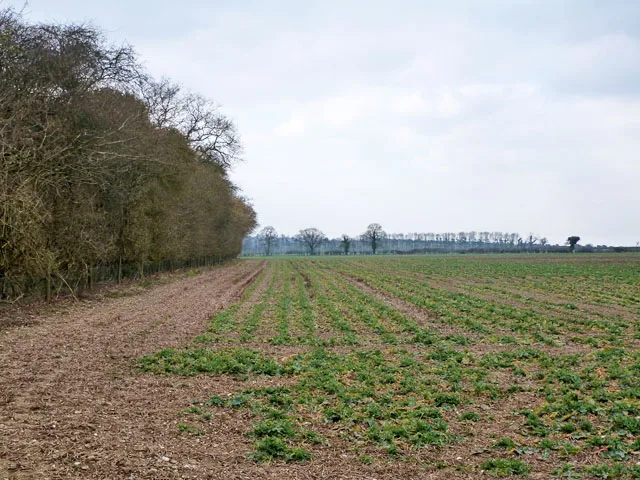

A 57,000 sq m warehouse up to 23m tall is planned on farmland by the A30 at M3 junction 7, with 1,695 HGV trips a day. Comments close 22 November.
A warehouse with up to 57,000 square metres of floorspace is planned on two arable fields beside the A30 at junction 7 of the M3, on the south-west edge of Basingstoke.
The outline application, 26/02040/OUT, was validated on 21 October. The applicant is St Monica Trust, which owns the land, and the agent is Savills. Comments can be made until Sunday 22 November.
The site is 21.7 hectares, between the A30 and the villages of Dummer and North Waltham. The building would sit directly across the A30 from the approved Oakdown Farm employment scheme.
What the application asks for
Only the access onto the A30 is fixed now. Everything else, including the look and layout of the building, would come back later as reserved matters. The planning statement and the environmental statement summary set out the limits:
- up to 57,000 sq m of storage and distribution floorspace (Use Class B8), including offices
- a building no more than 23 metres tall
- lorry and staff parking, service yards, drainage basins and new planting
- a dual carriageway access road from the A30, joining the Oakdown Roundabout already approved for the Oakdown Farm scheme
- a footway and cycleway along the A30, and a link to Trenchards Lane
The application comes with a full environmental statement, covering everything from air quality and noise to archaeology and flooding.
How much traffic it would bring
The developer’s transport chapter estimates the trips the finished warehouse would generate on an average day.
| Vehicles | Morning peak hour | Evening peak hour | Whole day |
|---|---|---|---|
| Cars and vans | 163 | 240 | 3,668 |
| Lorries and other heavy vehicles | 43 | 58 | 1,695 |
| All vehicles | 206 | 298 | 5,363 |
Each figure counts a trip in or a trip out. The 1,695 heavy vehicle trips are 853 arrivals and 842 departures. The developer offers up to £1.6 million towards a new daily bus every 30 minutes between the site and the town centre, with stops inside Oakdown Farm.
Jobs and money
The environmental statement says the warehouse would support about 360 net additional full-time equivalent jobs for borough residents once it is fully occupied. It also estimates £1.2 million a year in business rates kept by the council.
Why here, according to the developer
The site was part of the Southern Manydown allocation in the council’s 2025 draft Local Plan. That draft directed storage and distribution to the southern end of the allocation, next to the A30 and junction 7. Land in Southern Manydown is also earmarked by Hampshire Hospitals NHS Foundation Trust for a possible new hospital.
That draft plan no longer exists. On 8 September the council’s Cabinet agreed to start a new Local Plan under the new planning system, after South East Water, the Environment Agency and Natural England raised concerns about water supply. The new plan is not due to be adopted until 2029, as we reported when the scoping consultation opened.
Savills argues the old draft and its evidence still count. The council’s own 2025 site selection report said “the additional logistics floorspace is to be provided within the Southern Manydown allocation, in close proximity to junction 7 of the M3”. The same draft set a need for 177,000 sq m of new logistics floorspace across the borough by 2042.
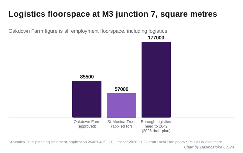
Oakdown Farm, application 23/03120/FUL, already has permission for about 85,500 sq m of employment floorspace including logistics, according to the planning statement. Between them, the two schemes would put more than 140,000 sq m of floorspace either side of the A30.
What is next to it
The summary lists what the developer had to assess around the site:
- Ganderdown Copse, ancient woodland and a county Site of Importance for Nature Conservation, adjoining the north-east corner
- a Grade II listed milestone on the A30 at Ganderdown
- Grade II listed Southwood Farmhouse to the north
- the Dummer and North Waltham conservation areas, including the Grade I listed All Saints Church at Dummer
- the Wayfarer’s Way long-distance path, and a public right of way along the south-west edge
Hampshire County Council’s archaeologist commented on 23 October, and Active Travel England sent its standing advice on 27 October. Both comments are on the application page.
What it means for you
- If you live in Dummer, North Waltham, Kempshott or Beggarwood, this is the scheme to read now. Outline permission would settle the principle and the access; later stages only deal with detail.
- If you drive the A30 or use junction 7, the transport chapter is where the lorry numbers are, link by link.
- To comment, use the “Make a comment” option on the application page or email planning.comments@basingstoke.gov.uk quoting 26/02040/OUT, by 22 November.
The council’s target date for a decision is 10 February 2027. How the council decides which applications go to councillors has changed this autumn: see our planning committee page. For the homes planned on the land next door, see Manydown South. Other live applications are on our Basingstoke planning applications page.
Have your say